
-
Research Article
-
Evaluation of the Relative Suitability of World Map Projections According to Central Meridian Setting: A Comparison of the Robinson and Winkel Tripel Projections
중앙경선 설정에 따른 세계지도 투영법의 상대적 적합도 평가: 로빈슨 도법과 빈켈 트리펠 도법의 비교
-
Yongmin Kim ⋅ Sang-Il Lee
김용민 · 이상일
- This study investigates how the choice of central meridian affects mean projection distortion over land and the relative suitability of map projections, …
본 연구는 중앙경선의 선택이 육지부의 평균 투영 왜곡도와 투영법의 상대적 적합도에 미치는 영향을 로빈슨 도법과 빈켈 트리펠 도법의 비교를 통해 실증적으로 분석하였다. …
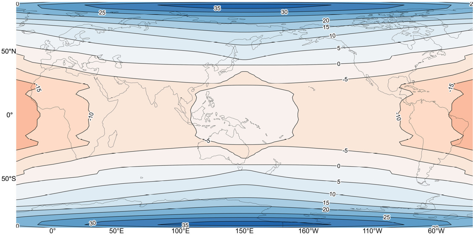
- This study investigates how the choice of central meridian affects mean projection distortion over land and the relative suitability of map projections, through a comparative analysis of the Robinson and Winkel Tripel projections. Local distortions—angular, areal, and scale—are defined using Tissot’s indicatrix and extended to mean distortions over global land areas via numerical integration. A three-dimensional computational framework is constructed by combining a latitude–longitude grid with a central meridian dimension, enabling systematic evaluation of distortion patterns across different meridians. The results show that distortion levels in both projections depend on the choice of central meridian. Angular distortion reaches a minimum near 30°E and a maximum near 130°W, with the Robinson projection outperforming the Winkel Tripel projection across most meridians except within a limited range. In contrast, areal distortion consistently favors the Winkel Tripel projection regardless of the meridian, and exhibits a spatial pattern opposite to that of angular distortion. These differences can be explained by the interaction between the intrinsic spatial distribution of distortion in each projection and the redistribution of landmasses caused by shifts in the central meridian. In particular, changes in the relative position of land areas—whether concentrated near the center or the edges of the map—significantly influence the overall distortion metrics. Based on this framework, the case of setting the central meridian to 150°E is evaluated. Under this configuration, the Robinson projection shows a clear improvement in angular distortion but a deterioration in areal distortion, resulting in a trade-off between distortion types. However, when greater weight is assigned to angular distortion in accordance with commonly used evaluation criteria emphasizing visual naturalness, the relative suitability of the Robinson projection improves compared to the prime meridian case. This study highlights the central meridian as a critical analytical dimension and provides a generalized methodological framework for reevaluating projection performance under varying meridian configurations.
- COLLAPSE
본 연구는 중앙경선의 선택이 육지부의 평균 투영 왜곡도와 투영법의 상대적 적합도에 미치는 영향을 로빈슨 도법과 빈켈 트리펠 도법의 비교를 통해 실증적으로 분석하였다. 이를 위해 티소의 지시타원을 기반으로 각도, 면적, 축척의 국지적 왜곡도를 정의하고, 수치적분을 통해 육지부 전체의 평균 왜곡도로 확장하였다. 또한 2.5° 간격의 경위도 격자망과 중앙경선 차원을 결합한 3차원 계산 체계를 구축하여, 중앙경선 변화에 따른 왜곡도의 분포를 체계적으로 산출하였다. 분석 결과, 두 도법 모두에서 왜곡도는 중앙경선의 설정에 의존하는 것으로 나타났다. 각도 왜곡의 경우 동경 30° 부근에서 최소, 서경 130° 부근에서 최대를 보이며, 일부 구간을 제외하면 대부분의 중앙경선에서 로빈슨 도법이 빈켈 트리펠 도법보다 우세하였다. 반면 면적 왜곡에서는 중앙경선의 위치와 무관하게 빈켈 트리펠 도법이 일관되게 우세하였으며, 두 왜곡 범주는 서로 상반된 공간적 분포를 보였다. 이러한 차이는 각 투영법이 지니는 고유한 왜곡의 공간적 구조와, 중앙경선의 변화에 따라 달라지는 수륙 분포의 재배치가 결합된 결과로 해석된다. 특히 중앙경선의 이동에 따라 육지부가 지도 중앙 또는 외곽으로 이동하면서 평균 왜곡도에 대한 기여 구조가 달라지는 점이 핵심적인 요인으로 작용한다. 이러한 분석을 바탕으로 중앙경선을 동경 150°로 설정한 경우를 평가한 결과, 로빈슨 도법은 각도 왜곡에서 상대적 개선을 보이는 반면 면적 왜곡은 증가하여 두 왜곡 속성 간 상충이 발생하는 것으로 나타났다. 그러나 각도와 면적 왜곡의 균형을 고려하되 각도 왜곡의 영향력이 더 크다는 평가 기준을 적용하면, 로빈슨 도법의 상대적 적합성은 본초자오선을 중앙경선으로 설정한 경우에 비해 높아지는 것으로 해석할 수 있다. 본 연구는 중앙경선을 투영 왜곡 분석의 핵심 변수로 도입함으로써, 투영법의 성능을 보다 일반화된 틀에서 재평가할 수 있는 방법론을 제시하였다는 점에서 의의를 가진다.
-
Evaluation of the Relative Suitability of World Map Projections According to Central Meridian Setting: A Comparison of the Robinson and Winkel Tripel Projections
-
Research Article

-
Exploring Research Trends on Address Information and Address Data in Korea Using LDA Topic Modeling
LDA 토픽 모델링을 활용한 국내 주소정보 및 주소데이터 연구 동향 탐색
-
Huiji Jeong · Seungmin Cha · Jungho Choi · Jeon-Young Kang
정희지 · 차승민 · 최정호 · 강전영
- With the development of spatial information technology and data, the concept of address is expanding beyond its conventional definition to encompass diverse …
주소는 공간정보 기술과 데이터의 발전으로 기존의 의미를 넘어 다양한 기능과 의미로 확장되고 있다. 특히, 새로운 주소체계 도입과 주소정보 및 데이터 고도화로 주소 …
- With the development of spatial information technology and data, the concept of address is expanding beyond its conventional definition to encompass diverse functions and meaning. In particular, despite the expanding scope of address research by the introduction of new address system and the advancement of address information and data, there is a lack of studies that comprehensively review the trend. To this end, we aim to provide a comprehensive analysis fo research topics related to address information and data by applying LDA topic modeling to titles and abstracts of academic papers published since 1997 in KCI, DBPIA and RISS. As a result, five topics were extracted from address information and six topics from address data, and these were structured using IDM. This study provides a synthesis of existing studies and contributes to establishing the direction of future research topics by examining overall trends in address-related research.
- COLLAPSE
주소는 공간정보 기술과 데이터의 발전으로 기존의 의미를 넘어 다양한 기능과 의미로 확장되고 있다. 특히, 새로운 주소체계 도입과 주소정보 및 데이터 고도화로 주소 관련 연구의 영역은 점차 확장되고 있으나, 이를 종합적으로 정리한 연구는 부족하다. 본 연구는 국내 학술논문 데이터베이스 KCI, DBPIA, RISS에 출판된 1997년 이후의 학술논문의 제목과 초록에 대해서 LDA 토픽 모델링을 활용하여 주소정보 및 주소데이터 연구의 토픽을 통합적으로 분석하고자 하였다. 분석 결과, 주소정보에서 5개, 주소데이터에서 6개의 토픽을 추출하였고, IDM을 통해 토픽들을 구조화하였다. 본 연구는 국내 주소 관련 연구의 전반적인 연구 동향을 파악함으로써 현재까지의 주소 연구 흐름을 종합하고 연구 주제의 방향 정립에 기여할 수 있다.
-
Exploring Research Trends on Address Information and Address Data in Korea Using LDA Topic Modeling
-
Research Article
-
A Study on Quality Assessment and Improvement Strategies for the National Points of Interest
국가관심지점정보 품질 진단 및 고도화 방안 연구
-
JongHyeok Son · Jiwon Lee · YoungJoo Lee
손종혁 · 이지원 · 이영주
- With the advancement of geospatial technologies, the role of Point of Interest (POI) data has expanded beyond map visualization to include policy …
공간정보기술의 발전에 따라 POI의 역할이 지도 표출을 넘어, 정책분석, 공간진단, AI 모델링 등으로 확대되고 있으나, 공공 POI인 국가관심지점정보의 품질은 이러한 수요에 충분히 …
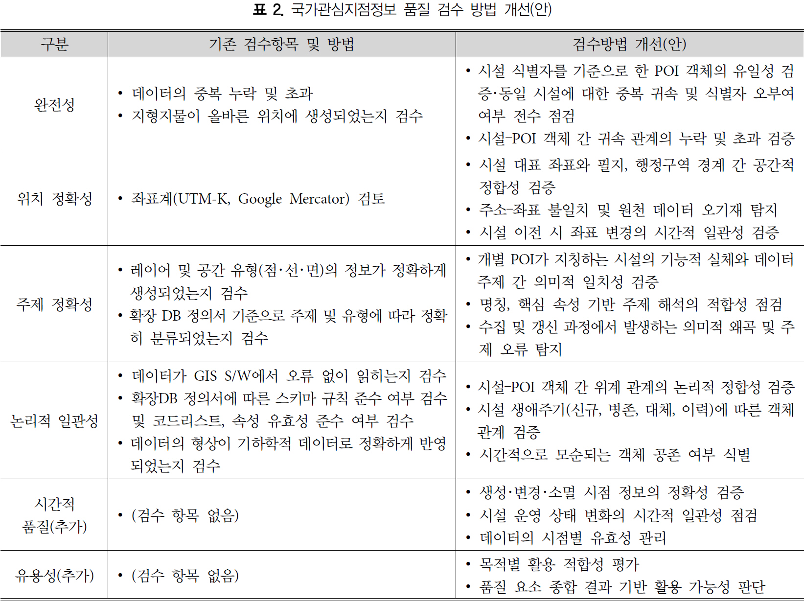
- With the advancement of geospatial technologies, the role of Point of Interest (POI) data has expanded beyond map visualization to include policy analysis, spatial diagnostics, and AI-based modeling. However, the quality of the public POI dataset, the National Points of Interest (NPOI), remains insufficient to meet these emerging demands. This study aims to diagnose the quality issues of the NPOI dataset and to propose directions for improvement. A review of the current quality management framework shows that although it adopts KS X ISO 19157, it is largely focused on schema and format conformity checks, which limits its ability to proactively identify and manage substantive quality issues such as duplication, positional errors, and classification inconsistencies. The NPOI dataset was further analyzed in terms of redundancy, positional accuracy, classification consistency, and temporal currency. The results reveal several issues, including cumulative duplication caused by repeated registration of identical facilities and the coexistence of legacy and updated records, positional inaccuracies due to erroneous source addresses, structural inconsistencies in the classification scheme where institutional, nominal, and functional criteria are mixed, and reduced timeliness resulting from delays in incorporating new facility types. To enhance the usability of the NPOI dataset, this study suggests improving the data collection and update framework, transitioning to a relational database–based data model, and advancing the quality management system to incorporate semantic, relational, and temporal dimensions.
- COLLAPSE
공간정보기술의 발전에 따라 POI의 역할이 지도 표출을 넘어, 정책분석, 공간진단, AI 모델링 등으로 확대되고 있으나, 공공 POI인 국가관심지점정보의 품질은 이러한 수요에 충분히 대응하지 못하고 있다. 이러한 배경에서, 본 연구는 공공 POI인 국가관심지점정보의 품질 문제를 진단하고 개선 방향을 제시하고자 한다. 먼저 현행 품질관리체계를 검토한 결과, KS X ISO 19157을 준용하고 있으나 스키마 및 형식 적합성 중심의 점검에 편중되어, 중복, 위치 오류, 분류 혼선과 같은 실질적 품질 문제를 사전에 식별하고 관리하는 데 한계를 보이는 것으로 나타났다. 이어 국가관심지점정보를 중복성, 위치 정확도, 분류체계 정합성, 최신성 관점에서 분석한 결과, 동일 시설의 반복 구축과 신·구 데이터 병존으로 인한 중복 누적, 원천 주소 오류에 따른 위치 오기재, 기관·명칭·기능 기준이 혼재된 분류체계의 구조적 불일치, 신규 시설 유형 반영 지연에 따른 시의성 저하 등의 문제가 확인되었다. 이를 해결하기 위해, 국가관심지점정보의 수집 및 갱신 체계의 정비, 관계형 데이터베이스 기반 데이터 모델로의 전환, 의미·관계·시간성을 반영한 품질관리체계의 고도화가 병행될 필요가 있음을 제안한다.
-
A Study on Quality Assessment and Improvement Strategies for the National Points of Interest
-
Research Article
-
A Spatial Analysis of Food Deserts in Seoul Integrating Physical and Digital Accessibility
물리적, 디지털 접근성을 반영한 서울시 식품사막에 대한 공간분석
-
Se Heon Kim · Youngho Kim
김세헌 · 김영호
- This study quantified physical and digital accessibility across 426 administrative dongs in Seoul and identified areas corresponding to food deserts based on …
본 연구는 서울시 426개 행정동을 대상으로 물리적 접근성과 디지털 접근성을 계량화하고, 두 접근성을 기준으로 식품사막에 해당하는 지역을 정량적으로 도출하였다. 물리적 접근성은 도보 …
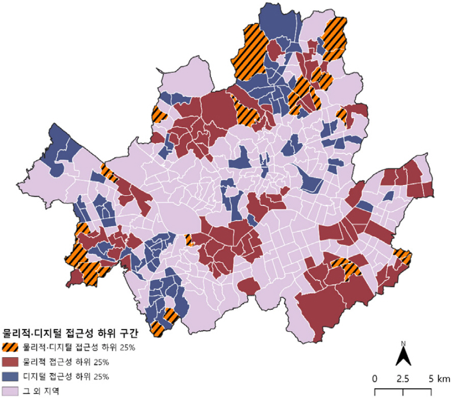
- This study quantified physical and digital accessibility across 426 administrative dongs in Seoul and identified areas corresponding to food deserts based on the combined levels of the two accessibility dimensions. Physical accessibility was calculated using the Gaussian Two-Step Floating Catchment Area (Gaussian 2SFCA) method incorporating pedestrian network distances. Digital accessibility was derived through principal component analysis (PCA) of standardized socio-demographic variables associated with digital service use. Each index was classified into quartiles, and a cross-classification was conducted to identify areas with low accessibility in both dimensions. The results indicate that areas with both low physical and low digital accessibility are distributed across Seoul. This suggests that when mobility-based access and digital access are simultaneously limited within the same area, the potential for substitution between the two access pathways becomes restricted. By integrating digital accessibility into conventional distance-based accessibility analysis, this study identifies areas with low food access that would not be detected using a single accessibility measure.
- COLLAPSE
본 연구는 서울시 426개 행정동을 대상으로 물리적 접근성과 디지털 접근성을 계량화하고, 두 접근성을 기준으로 식품사막에 해당하는 지역을 정량적으로 도출하였다. 물리적 접근성은 도보 네트워크를 반영한 Gaussian Two-Step Floating Catchment Area(Gaussian 2SFCA) 기법을 이용하여 산출하였다. 디지털 접근성은 디지털 기반 서비스 이용 수준과 통계적으로 연관된 사회·인구학적 변수를 표준화한 후 주성분분석(PCA)을 통해 지표를 산출하였다. 각 지표를 사분위로 구분한 후 교차 분석한 결과, 물리적 접근성과 디지털 접근성이 모두 낮은 지역이 서울 전역에 분포한다. 이는 오프라인 이동 기반 접근과 디지털 기반 접근이 동일한 지역에서 모두 낮게 나타날 경우, 접근 경로 간 보완이 제한됨을 의미한다. 본 연구는 거리 기반 접근성 분석에 디지털 접근성을 결합함으로써, 단일 접근성 지표로는 식별되지 않는 식료품 접근성이 낮은 지역을 도출하였다.
-
A Spatial Analysis of Food Deserts in Seoul Integrating Physical and Digital Accessibility
-
Research Article
-
Spatial Distribution and Residential Segregation of Language-Based Migrant Groups: Evidence from Russian-Speaking Migrants
언어 기반 이주민 집단의 공간적 분포와 주거지 격리: 러시아어권 이주민을 사례로
-
Dasol Kim · JongSung Kim · Kirl Kim
김다솔 · 김종성 · 김 걸
- This study extends existing research on immigrant residential patterns―traditionally focused on nationality and ethnicity―by examining the spatial distribution and residential segregation of …
이 연구는 국적·민족을 중심으로 축적되어 온 기존 이주민 주거지 연구를 확장하여, 러시아어권 이주민의 공간 분포와 주거지 격리 양상을 분석하였다. 러시아어를 공용어 또는 …
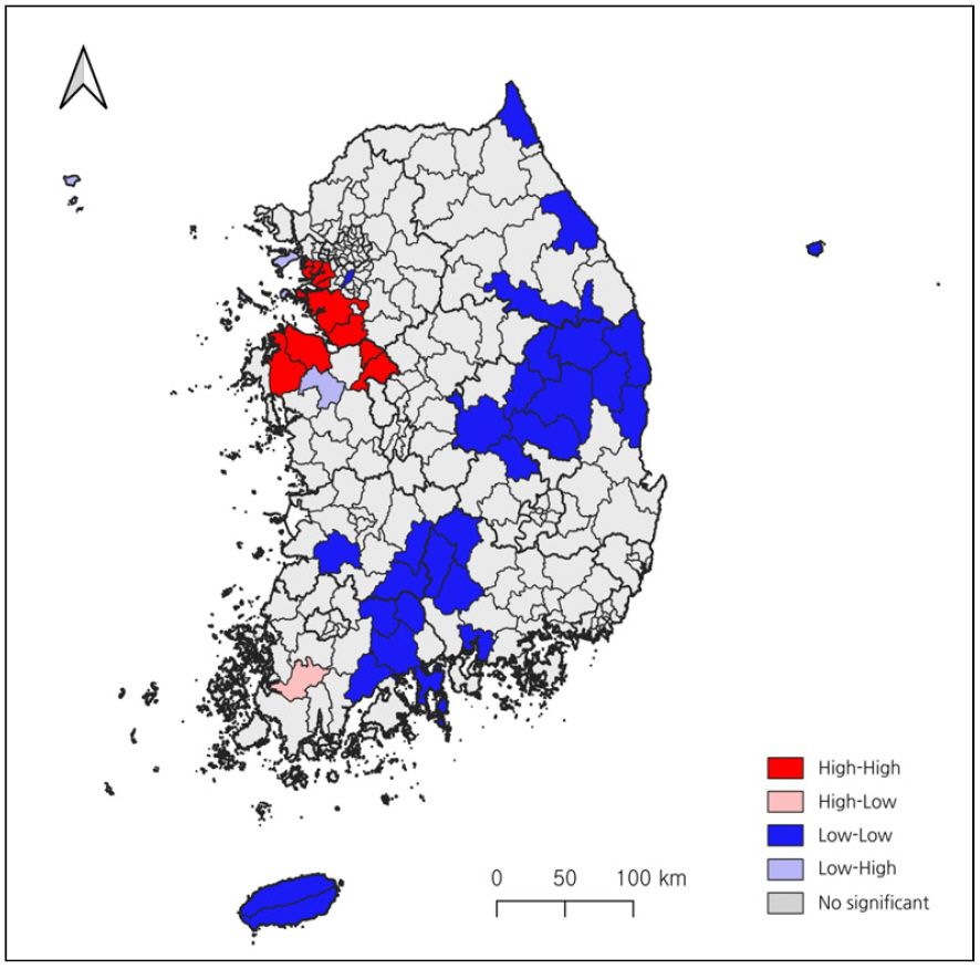
- This study extends existing research on immigrant residential patterns―traditionally focused on nationality and ethnicity―by examining the spatial distribution and residential segregation of Russian-speaking migrants in South Korea. Russian-speaking migrants are defined as long-term foreign residents from seven countries where Russian is an official or commonly spoken language, and the analysis covers the period from 2010 to 2024. Location quotients, the index of dissimilarity, and spatial autocorrelation measures are employed. The results show a rapid increase and spatial concentration of Russian-speaking migrants in specific regions. In 2024, the index of dissimilarity reached 0.5408, indicating a high level of residential segregation, while spatial autocorrelation analysis reveals clusters in southwestern Gyeonggi-do and northern Chungcheongnam-do. These findings suggest the potential emergence of language-based migrant enclaves and demonstrate the analytical usefulness of a language-based approach in immigrant spatial research.
- COLLAPSE
이 연구는 국적·민족을 중심으로 축적되어 온 기존 이주민 주거지 연구를 확장하여, 러시아어권 이주민의 공간 분포와 주거지 격리 양상을 분석하였다. 러시아어를 공용어 또는 상용어로 사용하는 7개국 출신 장기체류외국인을 러시아어권 이주민으로 정의하고, 2010년부터 2024년까지를 분석의 시간적 범위로 설정하였다. 분석에는 입지계수·상이지수·공간 자기상관지수를 활용하였다. 분석 결과, 러시아어권 이주민은 빠르게 증가하며 일부 지역에 선택적으로 집중되는 경향을 보였다. 특히, 2024년 기준 상이지수는 0.5408로 높은 주거지 격리 수준을 나타냈다. 또한 공간 자기상관 분석에서도 경기도 서남부와 충청남도 북부를 중심으로 한 공간적 군집이 확인되었다. 이는 향후 언어 기반 이주민 엔클레이브로 발전될 가능성이 크다는 것을 의미한다. 이 연구는 언어 기반 접근이 이주민 공간 연구에서 갖는 분석적 유용성을 실증적으로 제시한다.
-
Spatial Distribution and Residential Segregation of Language-Based Migrant Groups: Evidence from Russian-Speaking Migrants
-
Research Article
-
Estimating Small-area Populations Using Spatial Deep Learning-based Dasymetric Mapping
공간 딥러닝 기반의 대시메트릭 매핑을 활용한 소지역 인구 추정
-
Chan Lee · Gunhak Lee
이 찬 · 이건학
- Most rural areas have lower population densities than urban areas, and their settlement patterns are spatially dispersed. Due to these spatial characteristics, …
농촌지역은 도시지역에 비해 인구 밀도가 낮고, 정주 패턴이 분산되어 있다는 특징을 가진다. 이러한 경우에 국가 통계기관에서 제공하는 인구 자료만으로는 미시적 수준의 공간적 …
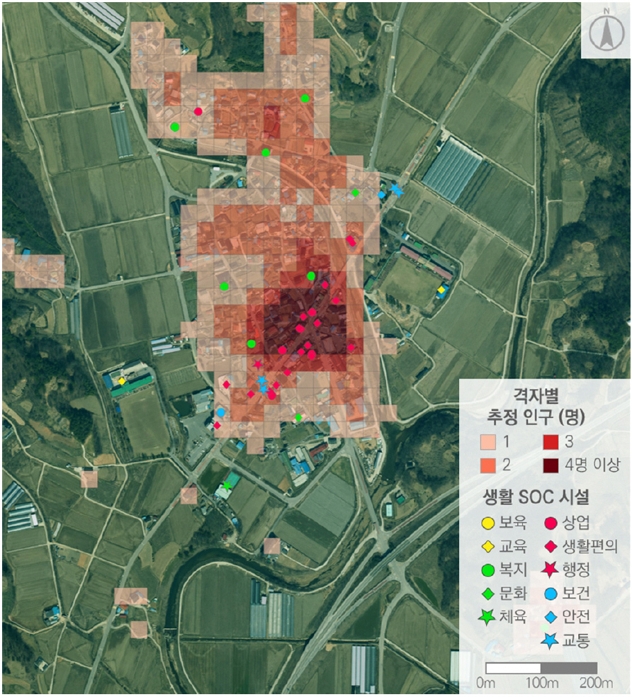
- Most rural areas have lower population densities than urban areas, and their settlement patterns are spatially dispersed. Due to these spatial characteristics, it is generally difficult to capture micro-level spatial variations using census data published by national statistical offices. Estimating such population distributions can benefit from several approaches. Among them, a dasymetric mapping could be a viable option, particularly for estimating populations in sparsely populated areas when meaningful auxiliary variables are available. Many previous studies on dasymetric population estimation have primarily relied on physical and environmental variables such as land cover, terrain, and road networks. In this research, we focus on variables representing essential living infrastructure (referred to as living SOC), which are expected to shape the spatial patterns of micro-scale population distributions in rural areas. This research aims to estimate the population with a small area unit in rural areas more accurately utilizing a spatial deep learning model integrated with dasymetric techniques. As results of case study, the graph neural network (GNN)–based dasymetric mapping approach explicitly learning spatial dependencies among grid cells. shows outstanding performance for estimating small-area population in rural areas, and living SOC variables embedded in this model can function as spatial anchors for explaining rural population distributions. Furthermore, this study is worth as the original attempt to validate micro-scale population distributions in Korean rural areas using observed tongban-level population data, where official small-area statistics are not available. The findings are expected to provide important implications for public planning and rural regeneration policies.
- COLLAPSE
농촌지역은 도시지역에 비해 인구 밀도가 낮고, 정주 패턴이 분산되어 있다는 특징을 가진다. 이러한 경우에 국가 통계기관에서 제공하는 인구 자료만으로는 미시적 수준의 공간적 변동성을 충분히 포착하기 어렵다. 농촌지역의 인구 분포를 추정하기 위해서는 다양한 접근 방법이 활용될 수 있으며, 그중에서도 대시메트릭 매핑은 의미 있는 보조 변수가 확보될 경우 저밀 지역의 인구를 추정하는데 유효한 방법이 될 수 있다. 기존의 대시메트릭 인구 추정 연구들은 주로 토지피복, 지형, 도로망과 같은 물리·환경적 변수에 의존해 왔지만 본 연구는 농촌지역 미시적 인구 분포의 공간적 패턴을 형성하는 사회적 인프라 영역인 생활 SOC 변수에 주목한다. 본 연구의 목적은 공간 딥러닝 모델을 대시메트릭 기법과 결합함으로써 농촌지역의 소지역 단위 인구를 보다 정확하게 추정하는데 있다. 사례 연구 결과, 공간적 의존성을 학습하는 GNN 기반의 대시메트릭 모델이 농촌지역의 소지역 단위 인구 추정에 탁월한 성능을 보이고 있으며, 이 모델에 적용한 생활 SOC 변수는 농촌 인구 분포를 설명하는 중요한 공간적 앵커로서 역할을 하고 있음을 확인하였다. 본 연구는 통반 단위 실측 인구 자료를 활용하여 추정 결과를 절대적으로 검증함으로써, 공식적인 소지역 인구 통계가 제공되지 않는 우리나라 농촌지역 인구 추정의 시초적 연구로서 의의를 가지며, 향후 농촌지역의 공공 계획 수립에 중요한 시사점을 제공할 것으로 기대된다.
-
Estimating Small-area Populations Using Spatial Deep Learning-based Dasymetric Mapping
-
Research Article
-
Map Use in the Geography Domain of Elementary Social Studies under the 2022 Revised Curriculum
2022 개정 교육과정 초등 사회과 지리 영역에서의 지도 활용
-
HaeJi Jeon · JaeYung Choi
전해지 · 최재영
- This study examines changes in the use of maps in the geography domain of elementary social studies by comparing textbooks developed under …
본 연구는 2015 개정 교육과정과 2022 개정 교육과정에 따른 초등 사회 교과서를 비교·분석하여 지리 영역에서의 지도 활용 양상의 변화를 고찰하였다. 분석 결과, …
- This study examines changes in the use of maps in the geography domain of elementary social studies by comparing textbooks developed under the 2015 revised curriculum and the 2022 revised curriculum. The findings indicate that the 2022 revised curriculum shows an increased use of digital maps-namely digital image maps and interactive maps-and a strengthened integration with digital tools such as augmented reality (AR), metaverse platforms, map applications, and statistical data. In addition, contemporary issues such as climate change and population problems are reconstructed in a problem-solving-oriented manner, with maps functioning as key tools for spatial understanding. These changes suggest a shift in map use from traditional understanding-centered approaches to digitally supported inquiry-based learning.
- COLLAPSE
본 연구는 2015 개정 교육과정과 2022 개정 교육과정에 따른 초등 사회 교과서를 비교·분석하여 지리 영역에서의 지도 활용 양상의 변화를 고찰하였다. 분석 결과, 2022 개정 교육과정에서는 디지털 지도, 즉 디지털 영상지도와 인터랙티브 지도의 활용이 확대되고, AR, 메타버스, 지도 애플리케이션, 통계 자료 등 디지털 도구와의 통합이 강화된 것으로 나타났다. 또한 기후변화와 인구 문제와 같은 사회적 쟁점이 문제 해결 지향적으로 재구성되며, 지도는 이를 공간적으로 이해하는 핵심 도구로 기능하였다. 이러한 변화는 지도 활용이 전통적 이해 중심에서 디지털 기반 탐구 중심으로 전환되고 있음을 시사한다.
-
Map Use in the Geography Domain of Elementary Social Studies under the 2022 Revised Curriculum

Journal Informaiton
 Journal of the Korean Cartographic Association
Journal of the Korean Cartographic Association


한국지도학회
Department of Geography, College of Science, Space 21, Kyung Hee University, 26, Kyunghee-daero, Dongdaemun-gu, Seoul 02447, Republic of Korea
Tel: +82-2-961-9123 / E-mail: journal.kca@gmail.com Copyright© The Korean Cartographic Association. Powered by APUB
Tel: +82-2-961-9123 / E-mail: journal.kca@gmail.com Copyright© The Korean Cartographic Association. Powered by APUB